This guided workflow document introduces the surveying functionalities of the Leica RTC700, designed to support efficient, accurate, and user-friendly field operations. It provides step-by-step instructions for key georeferencing workflows, such as setup over known points, target scan, target-based registration, and area scanning, leveraging the tight integration between the scanner and Leica Field360. The goal is to help surveyors streamline data capture, ensure reliable positioning, and maximize productivity directly on site.
Workflows
Setup over a known point
Setup over a known point
The Setup over a known point workflow enables precise georeferencing directly in the field by positioning the RTC700 scanner over a point with known coordinates.
By entering or selecting the control point in Cyclone FIELD 360, the setup is aligned to the project coordinate system after acquisition, reducing the need for post-processing.
This approach:
-
Ensures immediate spatial accuracy
-
Supports consistent alignment across multiple setups
-
Is particularly suited for survey-driven projects with established control networks
The assignment can be defined:
-
During setup creation
-
Via the Assignments table
Target scan
The Target scan workflow enables accurate georeferencing by actively scanning and measuring targets within the scene.
With RTC700 and FIELD 360, users can perform:
-
Single target scan
Targets are picked in 360° or 3D view, measured, and assigned to known coordinates directly in the field
-
Batch target scan
Multiple targets are measured automatically in a single operation, reducing manual interaction and field time
Targets are managed in the Target Manager:
-
Initially appear in the Pending tab after picking
-
Can be selected and measured in batch
-
After processing, move to the Review tab
In the Review stage, users can:
-
Inspect fitting results
-
Navigate to targets in the point cloud
-
Accept or reject targets as needed
This workflow separates target picking, measurement, and validation, improving efficiency while maintaining full control over data quality
Target to target link
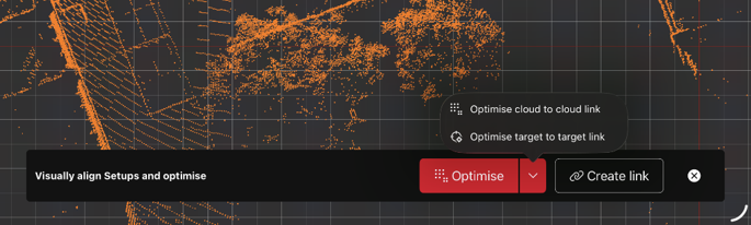
The Target-to-Target link workflow enables registration of multiple setups by linking shared targets across scan positions.
Once targets are measured and validated, FIELD 360 automatically links setups by matching identical target IDs. This creates a consistent geometric relationship between scans without requiring external control points.
This approach:
-
Supports incremental registration directly in the field
-
Provides robust alignment based on shared targets
-
Helps identify gaps or inconsistencies early in the workflow
Area Scan
The Area Scan workflow allows users to capture high-resolution data for selected regions of interest within a scene.
Using the panoramic view of the dual-dome scan, users can define a specific area and trigger a focused rescan with increased point density.
This enables:
-
Targeted data capture where higher detail is required
-
Reduced overall scan time and data volume
-
Efficient use of storage while preserving accuracy in critical areas
The high-resolution area is seamlessly integrated into the original scan and can be managed independently within the Data Browser.
Target fitting on mobile device with full data
Cyclone FIELD 360 now supports target fitting directly on the mobile device using full-resolution scan data.
Once full data is downloaded from the scanner, users can:
-
Perform target detection and fitting on-device
-
Validate results without additional scans
This capability is particularly relevant for RTC300 and RTC500 workflows, where dedicated target scans are not available.
By enabling target fitting on mobile:
-
Time on site can be reduced
-
Field workflows are streamlined
-
Results can be verified immediately