AUTOCAD BASIC AUTOCAD PRO REVIT navisworks bricscad basic bricscad pro ULTIMATE
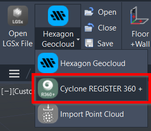
Project | Connect To… | Cyclone REGISTER 360 +
Command Line
-
AutoCAD / BricsCAD: CWIMPORTREG
This command enables point cloud data from Cyclone REGISTER 360 PLUS to be opened directly in the preferred CAD software.
Note: To use this option, the user needs to have Cyclone REGISTER 360 PLUS installed on the same computer.
Only Cyclone REGISTER 360 PLUS projects with a point cloud created during Finalized Registration can be accessed.
Using the Tool
To open the Cyclone REGISTER 360 PLUS project from CloudWorx, follow the steps below:
-
Select Cyclone REGISTER 360 + in the Project panel or type a command line prompt specific to the preferred CAD system and press ENTER.
-
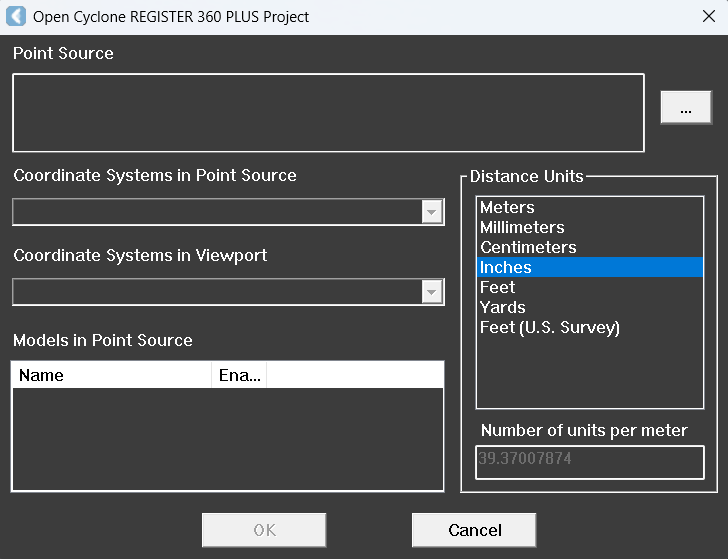
The Open Cyclone REGISTER 360 PLUS Project dialog appears.
-
-
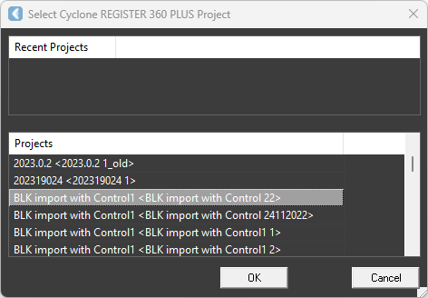
Click the browse icon (…) to the right of the Point Source field. The Select Cyclone REGISTER 360 PLUS Project dialog appears.
-
Select the desired project with the correct Finalized Registration.
-
The Finalized Registration name is within the angle brackets < > of the full title.
-
-
Click OK. It returns to the Open Cyclone REGISTER 360 PLUS Project dialog; the Point Source is updated with the selected project.
-
Select the appropriate option for the coordinate system in the Coordinate Systems in Point Source field.
-
This drop-down menu contains all the saved coordinate systems attached to the source Finalized Registration. The selected coordinate system will be mapped to the drawing's WCS.
-
Specify a coordinate system in the host software in Coordinate Systems In Viewport.
-
Select the preferred drawing unit in the Distance Units field, and the point cloud data will be scaled to the CAD drawing.
-
Distance units are needed to convert the units in Cyclone REGISTER 360 PLUS to the units in the preferred CAD software.
-
-
Ignore Models in Point Source. This option is not applicable to this import type.
-
Click OK to load the point cloud from the Finalized Registration.
-
Use the ZOOM | EXTENTS CAD command to view the entire scene.
All the cloud points and other related data, including the clippings and named user coordinate systems, will be loaded into CAD software.
All the named user coordinate systems in the Finalized Registration will be mapped to the CAD user coordinate systems, prepended by "~".