

What’s New
PinPoint 5.0.0 is a major release that introduces numerous enhancements to PinPoint functionality, including:
Improved cleanup workflows, including new options for backing cleanups, AI-assisted people detection filter, scan origin visualisation in Lasso Mode, and so on
Support for calculating floor plan room areas according to country-specific standards
Comprehensive new georeferencing workflow
Support for simple 3D measurements in PinPoint Registration Tool
New measurement and polyline tools in Sketch view in PinPoint Modeler
Possibility to recalculate kinematic scan panoramas after applying cleanups
Introduction of the Software Improvement Program aimed to guide future PinPoint releases
And many more improvements to enhance stability and streamline supported workflows.
all Pinpoint
Improved Cleanup Experience
This release improves the data cleanup workflow by consolidating filtering and cleanup functionality, resulting in the following updates and enhancements:
Automatic Filters Migrated to Cleanups
Automatic filtering functionality has been integrated into the classification cleanup workflow. The former Filter Points dialog, which included tools for range filtering, isolated point removal, small object/clutter removal, and ghost geometry cleanup, has been retired. These capabilities are now available as classification cleanups and can be managed alongside other cleanup operations.
The updated workflow includes a live probability-threshold slider and real-time on-screen preview, enabling users to immediately see the impact of changes before applying them.
Note: To ensure a seamless transition, existing filters will be automatically converted to their equivalent classification cleanups when an older project is opened for the first time.
Multiple Cleanups Management
Multiple classification cleanups can now be applied simultaneously, making it easier to review and compare cleanup results. Previously, activating one cleanup automatically deactivated any other active cleanup.
To switch between cleanups and edit a specific cleanup, users should now select the hand icon.
New Cleanup Baking Options
Cleanups can now be baked using the new Bake Applied Cleanup(s) and Undo Cleanup Baking options available when right-clicking the Cleanups section.
Baking a cleanup permanently applies the combined result of all active cleanup operations (lasso, mirror, plane, sphere selection, etc.) directly to each point, instead of evaluating them sequentially at runtime. This greatly improves performance on large point clouds with many cleanups.
Once a cleanup is baked, it becomes locked and is marked with a lock icon. Baked cleanups cannot be edited, enabled, disabled, or deleted until they are unbaked.

Note: Baked filters will not be migrated automatically when opening an old project in the new version for the first time. Those points will become visible again and must be re-baked. To do this, right-click the active cleanup(s) and bake it/them again.
Scan Origin Visualisation in Lasso Mode
Scan origin visualisation is now available in Lasso mode. While performing cleanup operations, users can hold CTRL and hover over any point to display a ray indicating the scan position from which that point was captured. The ray remains visible until the next click, making it easier to inspect scan origins without leaving Lasso mode.
Improved Mirror (Occlusion) Cleanup
The cleanup operations in mirror mode are now more flexible, allowing users to draw freely, work with multiple polygons simultaneously, and choose between free-draw and fixed-plane workflows. Specifically, users can:
Draw multiple polygons and apply them all at once.
Undo the last placed vertex or the last completed polygon.
Use the Minimal offset slider with an on-screen visualisation of the offset effect.
Use a fixed-plane mode, which allows to define a plane first and then draw multiple polygons on it.
Preview imported occluder mesh polygons before applying them.
AI-Powered People Cleanup
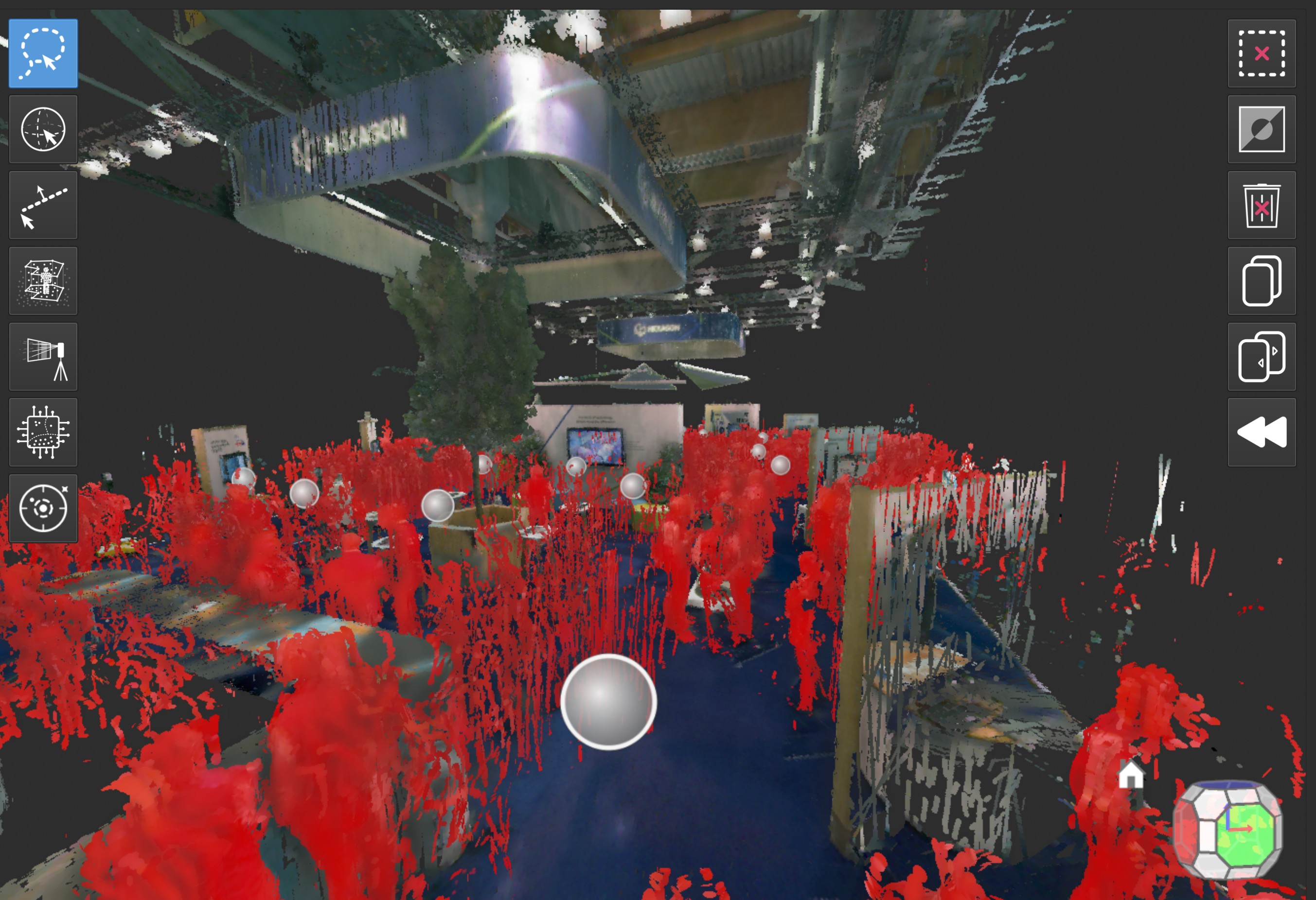
A new AI-powered cleanup filter has been introduced to help identify and remove people from point cloud data. The AI classifier analyses the data points and indicates the likelihood that a particular point represents a person. Users can adjust the classifier’s confidence level with a slider, which determines how strictly the classifier identifies and removes people from the dataset.
Classification is performed only on points that have not already been removed by other cleanup operations. If the set of uncleaned points changes, the classification can be recomputed by selecting the corresponding check box.
The AI-generated results can also be refined using manual cleanup tools, allowing users to add or remove points from the suggested cleanup as needed.
Enhanced Control Points Workflow
The Control Points workflow has been thoroughly redesigned to improve point cloud georeferencing and kinematic scan verification against measured control points.
Users can now import control points from external files or define them directly in PinPoint. The new workflow supports Leica, natural, and 3D spherical targets.
Leica targets are detected in images across the entire point cloud and assigned to their corresponding control points automatically. If the automatic assignment is incorrect or unclear, there is an option to manually reassign an observation to a different target. Natural targets, arbitrary point features with no physical targets, can be easily defined in a dedicated 3D image viewer that enables precise target selection directly from images. Once selected, natural target positions can be refined against neighbouring candidates in image space.
To ensure easy management of project control points, it is now possible to reorganise them using drag-and-drop functionality, as well as perform bulk operations through multi-selection. In addition, residual values are displayed for each control point after adjustment, providing clear visibility into the deviation between measured and computed positions and helping users assess registration quality on a per-point basis.
Support for Country-Specific Floor Plan Area Regulations
The Floorplan tool has been enhanced to support living space calculations for multiple countries. PinPoint now calculates the living area of a floor plan according to the national standard selected from a drop-down list available when opening the tool.
In addition to the fully validated German regulations, this release introduces 21 country-specific calculation standards. While these configurations are based on the respective published regulations, they are currently classified as experimental because they have not yet been validated against official reference calculations.
To support customisation and future enhancements, each country configuration is provided as a separate, editable file. This allows users to review and adjust calculation settings if the default rules do not fully meet their specific requirements.
Note: If a country configuration file is modified, it is strongly recommended to rename both the file and the corresponding ID defined within it. This ensures that custom configurations are not overwritten when updated default configurations are delivered in future releases.
To view the implemented regulations, refer to the dedicated Help page.
Software Improvement Program
Starting with this release, the Software Improvement Program is introduced to help enhance the overall user experience and guide the development of future product features, commands, and workflows. By participating, users can provide valuable insights that help shape future PinPoint releases.
User privacy is important to us. All data collected through the program is anonymised and cannot be used to identify users, obtain personal information, or contact participants directly.
The Software Improvement Program prompt appears the first time a user launches PinPoint 5.0.0 after installation. 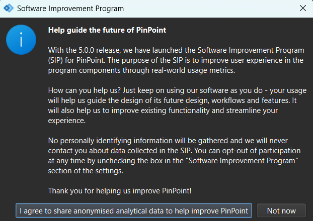
Participation can also be enabled later in Settings | Software Improvement Program by selecting the corresponding check box. Users can opt out at any time from the same settings page.
Pinpoint registration tool
Trajectory Panorama Regeneration
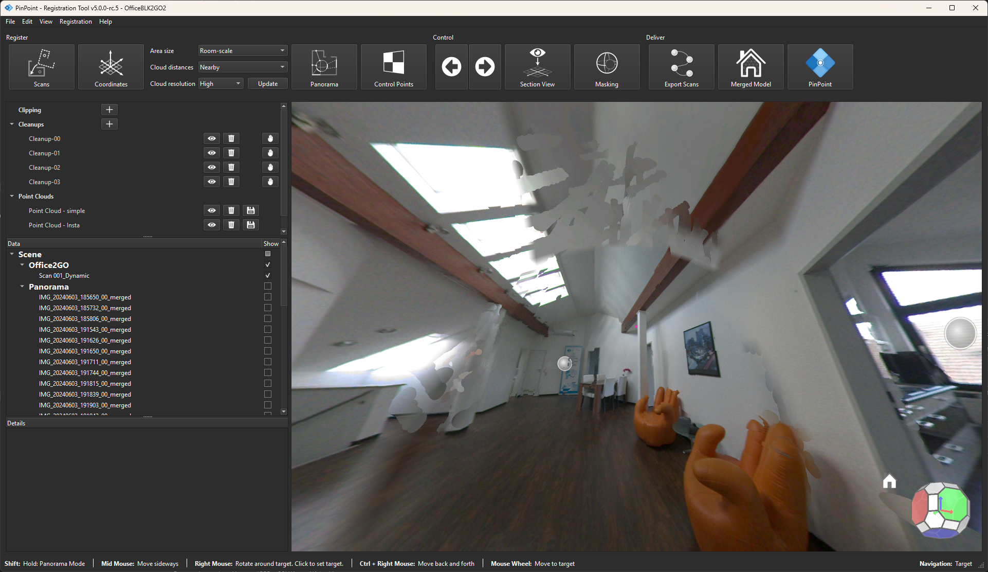
A new Recompute Panoramas context-menu option has been added for trajectory scans, making it possible to regenerate panoramic images after registration from the current, cleaned-up point cloud, so they reflect the latest geometry.
Because trajectory-based scans are captured while moving, they leave gaps in spherical coverage that a single fixed scan wouldn't have — most notably around the operator. PinPoint fills these gaps by reconstructing the missing image data from the point cloud itself. As a result, cleaning up the point cloud not only sharpens stitching across the panorama but also improves the quality of these reconstructed regions.
To regenerate panoramas:
Right-click the selected scan.
Select Recompute panoramas for 1 trajectories from the context menu.
In a confirmation dialog, adjust the waypoint spacing, if needed.
Click OK to render new panoramas.
To prevent data loss, recomputation is skipped for scans that do not contain camera frames required for panorama generation, leaving existing panoramas unchanged.
Original panorama
.png)
Regenerated panorama
pinpoint Modeler
Measurement and Polyline Tools Now Available in Sketch View
This release provides users with the opportunity to measure and sketch directly on 2D point-cloud projections in PinPoint Modeler.
The Sketch view now includes the following tools:
Measure tool
Mirroring the existing 3D Measure tool, it allows users to measure distances between two points, angles between two lines, and point-to-line distances. Measurements snap to extracted lines and their intersections to help ensure accurate results.
Polyline tool
This tool allows users to draw open polylines and closed polygons directly on the sketch. Geometry snaps to extracted lines and intersections, while segment lengths are displayed in real time during drawing. Users can create precise geometry by directly picking points, adjusting the snap radius, or entering exact segment lengths. When a polyline is closed, the resulting polygon automatically displays its perimeter and area. Multiple independent polylines and polygons can coexist within the same sketch, making it easy to document adjacent or nested spaces.
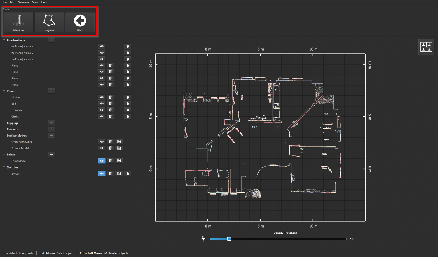
Using these tools, users can also extend existing sketches with additional projections by combining various projection types—such as point projections, orthophotos, and height slices—into a single sketch. This approach allows layering visual information and, as a result, capturing additional detail without creating separate sketches.
Additionally, the created sketches can be exported to DXF format, preserving all measurements, polylines, and polygons included in the sketch.