
July 3, 2024 | Reality Cloud Studio

What’s New
This is a weekly release including improvements and bug fixes.
Improved user-facing messages
The wording of certain user-facing messages have been improved to provide more information to the end user and improve their ability to address the issue.
Export .bytes mission planning file
Users can now export a 3D Map .bytes file from a processed BLK ARC B2G which contains mission planning information to support autonomous mission execution.
To start an autonomous mission without a physically Fiducial onsite, BLK ARC can now localize itself by importing a 3D map file (*. bytes). Visual initialization is an alternative solution to the existing Fiducial 200 method. It is the recommended workflow for repeatable missions, where the last scan from the mission can be used as a 3D map for subsequent iterations, as well as for sites, where keeping Fiducial in place for long time is not possible due to existing conditions. To successfully perform the mission till the end, the visual initialization must be performed together with pose optimization.
For this purpose, it is recommended to use the same scan file (B2G) for 3D model and 3D map creation. 3D maps used for this feature can be created automatically from a scan file (B2G) coming from either the BLK ARC or BLK2GO sensor, or exported from Reality Cloud Studio.
To access this file, select⋮and then Export from the Project menu or the Export button from within the asset and select 3D Map.

Project Menu

Export from Asset
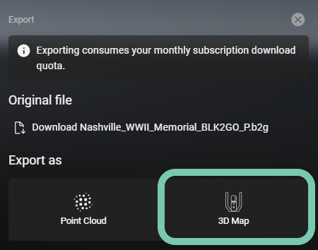
Exporting a .bytes file will consume data from a user’s subscription.
Center Camera View
Users can now return to the viewing position used when creating a GeoTag, Limit Box or Measurement to quickly orient to the object and understand the context in which it was created.
Open the Limit Box, Measurement or GeoTag menu.
Identify the object of interest.
Select the
⋮button.Select Center view.
Bug Fixes
Fixed a bug that caused General Access to become disables when exiting an Asset or refreshing the page causing those links to become invalid. The General Access setting remains enabled until disabled by the user.
Assets which have failed to process now have a red exclamation point as their thumbnail to better indicate to the user that the asset needs attention and was not successfully processed.
Fixed a bug that prevented some Tour presets from being successfully completed.