Skip table of contents

Release Notes | Cyclone REGISTER 360

Archive

What’s New

The 2026.0.0 version is a major release of Cyclone REGISTER 360 PLUS, introducing a wide range of enhancements, including updated GeoTag functionality, project update guidelines for compatibility with this version, two-target registration support, updates for SEMA export, integration of FAFx file import, image fidelity improvements, new settings, UI enhancements, common bug fixes, and more.

New GeoTag Functionality

Starting with version 2026.0.0, Cyclone REGISTER 360 PLUS introduces an upgraded GeoTag functionality that delivers more flexibility, structure, and clarity when working with point clouds.

Key benefits include:

  • Enhanced organisation and information accessibility maintained across workflows: The ability to identify and categorise specific assets in complex datasets.

  • Streamlined deliverable creation and maintenance: Creating GeoTags that are linked to relevant data and information, such as BIM deviations, analysis reports, maintenance schedules, operational status, warranty information, and so on.

  • Greater precision and context: Categories and parameters allow for more detailed descriptions of spatial objects.

  • Improved data organisation: The Category Manager enables structured, visually clear information management.

  • Richer documentation: The ability to attach files, links, and multimedia assets provides a more complete representation of inspections, conditions, or events.

  • Seamless project migration: Automatic conversion of legacy GeoTags ensures continuity without data loss.

  • Compatibility with the Leica Geosystems ecosystem: Export to LGSx format supports the new GeoTag structure, facilitating integration with other Leica Geosystems tools and external platforms.

These improvements transform GeoTags from simple spatial markers into comprehensive carriers of technical, inspection, and visual information.

Lossless Data Flow

The new GeoTag system in Cyclone REGISTER 360 PLUS is fully aligned with the unified, lossless data flow implemented across the reality capture ecosystem. This enhancement ensures that GeoTags are now fully interoperable, exchangeable, and portable across all major Leica Geosystems software solutions, including Cyclone FIELD 360, TruView, and Reality Cloud Studio.

The improved GeoTag architecture enables a seamless end‑to‑end experience, allowing users to capture, manage, review, and share contextual information without any conversion steps or data degradation. GeoTags created in the field can be consumed in the office or cloud applications exactly as captured, maintaining attributes, structure, spatial references, and media attachments in full fidelity.

This unified approach strengthens cross‑workflow collaboration, simplifies project handovers, and ensures that all stakeholders operate using a single, consistent information model.

GeoTag Categorisation

Now GeoTags can be assigned to many categories, which are divided into two types:

  • Predefined categories

These categories are available in the drop-down list and contain configurable definitions consisting of a key (e.g., Fire Safety Equipment) and a list of values (e.g., Powder extinguisher, Foam extinguisher, Hydrant).

  • Free text categories

Users can define their own category (e.g., Next inspection date) and assign a value in the form of a text string.

For more information on working with categories, refer to the Category Manager and GeoTag Categorisation Help pages.

Multi Asset Support

Now, multiple assets can be attached to a single GeoTag. All assets are opened outside the Cyclone REGISTER 360 PLUS environment, using the default system applications associated with each file type. This allows users to view and edit materials using their preferred tools.

Assets can be sourced from different locations, including:

  • Existing resources within the current project

  • Local disk

  • External resources

Supported Asset Types

Type

Format

Images

.jpeg, .jpg, .bmp, .png

Documents

.pdf, .txt

Video

.mp4

Audio

.mp3, .m4a

URL links

Any valid web address

For more details on managing assets, refer to the Working with Assets Help page.

Backward Compatibility with Previous GeoTag Versions

The new GeoTag functionality has been designed with full backward compatibility in mind. Projects created in earlier versions of Cyclone REGISTER 360 PLUS (for example, 2025.0.1 and earlier) are automatically converted to the new GeoTag format when opened.

Conversion Process

  • Conversion is automatic and requires no user intervention

  • All existing GeoTag data is preserved

  • New features, such as categories or assets, are added to converted GeoTags

Field Mapping Between Versions

To ensure a smooth transition to the new GeoTag structure, a built-in conversion mechanism automatically maps fields from older versions to the new format. This process preserves all relevant data and adapts it to the enhanced capabilities of the updated system.

LGSx Export Functionality for GeoTags

GeoTags created or converted to the new format are fully included in the LGSx file. The export process covers:

  • Categories (both predefined and free text)

  • Assigned assets (files, links, multimedia)

  • Descriptions and metadata

GeoTag Conflict Management During Project Import

When importing a project that contains GeoTags with categories, Cyclone REGISTER 360 PLUS now compares the imported data with the existing data in the current project. If differences or potential conflicts are detected, the system automatically applies a set of conflict‑resolution rules to maintain consistent, non-duplicated data.

The table below summarises the conflict types and the resolution logic used.

Conflict Type

Description

Applied Logic

Same category ID, different names

The same category has a different name in the imported project than in the existing project.

The system keeps the version with the latest modification time.
The older name is replaced.

Different list values

A category defined as a list contains different sets of values in both projects.

The system merges all unique values into a combined list.
If a value exists in both lists but has different UIDs, the value with the latest modification time is kept.

Priority conflicts

The same values exist, but their priorities differ between the current and imported projects.

The system keeps the priority order from the most recently modified version.

Overlapping priorities

Two different category values share the same priority.

The latest modified value keeps the priority.

The older value is given a new priority to remove duplication.

Same name, different IDs

Two categories have different UIDs but the same name.

The system keeps only one category and merges data based on modification time.
The imported category is adjusted or merged to prevent duplication.

Category name equals Field name

A category and a field (Free Text) share the same name.

The imported field is automatically renamed by appending – Copy to ensure unique names.

If two fields have the same name, the imported one also receives the -Copy suffix.

Project Update Required for Compatibility with Version 2026.0.0

Cyclone REGISTER 360 PLUS now uses an updated point cloud library. This improvement enhances performance and significantly reduces project size growth after cleaning operations. To take advantage of it, existing projects need to be updated.

Important:

  • Updated projects are compatible with version 2026.0.0 and later. They cannot be opened in previous versions.

  • When version 2026.0.0 is installed, the update process will not happen automatically. It is necessary to update each project manually (see the instructions below).

Before starting the project update process, take into account the following information:

  • It is recommended to back up the existing projects.

  • Projects that require updating will be marked with a red X (in the upper-left corner of the project preview) in the project list.

  • Projects that are not opened or updated will remain compatible with older versions.

How to Update a Project

  1. Install Cyclone REGISTER 360 PLUS 2026.0.0 and open it.

  2. Navigate to the project area where updates are managed.

  3. Select the project you want to update and click Open.

  4. Confirm the project update when the confirmation dialog appears.

  5. Once confirmed, Cyclone REGISTER 360 PLUS will:

5.1.  Convert the project using the new point cloud library.

5.2.  Use a temporary file during the conversion to ensure data integrity.

If all files are successfully updated, the system replaces the original files in the main project storage folder and displays the Process completed dialog. If any file fails, the update is aborted, and the original project remains unchanged.

Note: Ensure sufficient disk space in the temporary folder. This is especially important for large projects or when updating the entire Project Storage folder. Lack of space may cause the update to fail.

  1. Repeat Steps 3-4 for each project you want to update.

For more details and helpful tips, refer to the Updating Projects in Cyclone REGISTER 360 PLUS 2026.0.0 Help page.

Two-Target Registration Support

Cyclone REGISTER 360 PLUS now supports registration using only two targets, reducing the previous minimum requirement of three. This enables more flexible workflows, especially for P-Series scanners and low-overlap datasets, as well as for target‑only registration workflows where Cloud‑to‑Cloud alignment is not an option.

To enable two-target registration, a new setting, Allow 2 target linking of Setups upon import or post import, has been introduced in the Links settings. When this option is enabled, Cyclone REGISTER 360 PLUS allows Links to be created with only two targets. When the option is disabled, which is the default state, a minimum of three targets is required to form a valid Link.

image-20260203-102116.png

Workflow Overview

To register Setups using only two targets, follow the steps below:

  1. Import a dataset (for example, in E57 format).

  2. Extract and name targets consistently across Setups (for example, T1 in Setup A matches T1 in Setup B).

  3. Use the Match Targets option to create Links.

  4. Optimise the Bundle to finalise registration.

Handling Errors

If a Link created with two targets shows high registration errors, consider the following options to fix it:

  • Delete the Link.

  • Re-match targets manually.

  • Re-optimise the Bundle.

Support for FAFx File Format Import

Cyclone REGISTER 360 PLUS now supports the FAFx file extension generated by the latest version of Cyclone FIELD 360. The FAFx format (formerly FAF – Field Archive File) enables importing data with the new GeoTag structure, including:

  • Flexible GeoTag categorisation

  • Multiple asset types within a single GeoTag, such as images, videos, audio, text, PDFs, and URLs

This enhancement ensures seamless data transfer from Cyclone FIELD 360 to Cyclone REGISTER 360 PLUS, enabling import of the full dataset, including scans, images, and project information.

Streamlined SEMA Export

Exporting data in the SEMA format is now supported directly with a standard Cyclone REGISTER 360 PLUS license. The previous requirement for an additional Cyclone WORKFLOW license has been removed, making SEMA export accessible to more users.

Configurable B&W Target Diameter

This release introduces a new option in Settings | Links | Target Options, which enables the selection of the diameter for black‑and‑white (B&W) targets. The feature, labelled B&W target diameter, allows choosing between 4.5-inch and 6-inch target sizes to ensure more accurate recognition based on the actual physical targets used in the field. It can be applied either during automatic B&W target detection on import or during manual target extraction after the data has been imported.

This enhancement provides greater flexibility and improves reliability when processing data captured with different B&W target dimensions.

image-20260204-102027.png

ZMO Support

Cyclone REGISTER 360 PLUS now supports Zeno Mobile One (ZMO) data, enabling a powerful workflow enhancement for geospatial professionals. This feature ensures seamless import and utilisation of geolocated survey data, GeoTags, and linework models collected in the field using FLX100 and ZMO devices.

What Are ZMO and FLX100?

Zeno Mobile One (ZMO) is an application used for collecting geospatial features, such as points, lines, and polygons. It works together with the Zeno FLX100, a Leica GNSS data collector capable of providing positional accuracy down to 2 cm. Collected information is stored in Feature Layers, each defined by its own set of attributes and optional attachments. When exported, the data is packaged into a ZIP file that contains ESRI shapefiles, all related attachments, and the accompanying database.

This integration supports:

  • Survey Control creation from ZMO ZIP files

  • GeoTag enrichment and attachment handling

  • Hidden linework model import

Step-by-Step Workflow of Using ZMO Data in Cyclone REGISTER 360 PLUS

  1. Collecting field data:

  • Use FLX100 and ZMO to collect control points and features.

  • Organise data into layers (for example, GCP or Control for Survey Control).

  1. Importing data into Cyclone REGISTER 360 PLUS:

  • Add the RTC360 data and drag and drop the ZMO ZIP file into the Import area.

  • In General settings, enable the Add Target at Setup position option.

  • In the Properties panel, disable the Auto B&W Target option.

  • Cyclone REGISTER 360 PLUS automatically creates:

    • Survey Control from point geometries.

    • GeoTags with attachments (images, movies, PDF documents).

    • Models from linework layers.

  1. Applying Survey Control:

  • Targets from scan data are matched to Survey Control points.

  • If matched successfully, a User Coordinate System with a Coordinate Reference System (CRS) is created.

  • Control Tags and models become visible and are included in the deliverable (LGSx).

Notes:

  • Layer naming: Only layers named GCP or Control are used for Survey Control.

  • Fallback: If no such layers exist, all point geometry layers are used.

  • Target matching: Targets from scan data (e.g., B&W targets) are matched to Survey Control points.

  • Transformation: Successful match transforms the project into Survey Control coordinates.

  1. Handling GeoTag and attachments:

  • ZMO attachments (images, PDFs, videos) are converted to GeoTags.

  • GeoTags are linked to Survey Control and visible in the Setup View if control is applied.

  1. Importing linework models:

  • Linework (polylines, polygons, points) is imported as hidden models.

  • Models are attached to Survey Control and included in deliverables only if control is applied.

TruView Desktop Viewer Support

  • ZMO Survey Control, GeoTags, and models are fully integrated into LGSx files.

  • Users can inspect, measure, and export ZMO data.

  • Linework is now visible and navigable in TruView Desktop.

Support for NVIDIA GeForce RTX 5000 Series in Classification

Cyclone REGISTER 360 PLUS now officially supports the NVIDIA GeForce RTX 5000 series graphics cards for classification. This update ensures that users operating on RTX 5000 hardware can reliably run point cloud classification without compatibility concerns.

Automatic UCS Creation When Applying Control

Cyclone REGISTER 360 PLUS now automatically creates a User Coordinate System (UCS) whenever Applied Control is successfully applied. This gives users full visibility and control over the UCS generated from Applied Control, allowing it to be toggled on or off and used exactly like any standard UCS.

Key Details:

  • After Control is applied, a new UCS is added to the UCS list with the same name as the Applied Control entry (for example, Applied Control 1).

  • The UCS also appears in the left panel, consistent with all standard UCS entries.

  • If the Applied Control is recalculated (for example, by unchecking/rechecking targets and clicking Re-apply Control, the corresponding UCS automatically updates to reflect the new Applied Control result.

For more details, refer to the Automatic UCS Creation When Applying Control Help page.

Adding Level Condition to Imported Setups

Cyclone REGISTER 360 PLUS now supports manual assignment of the level condition to Setups imported without it. From the Setup context menu, users can select the Use Leveled Condition option and enable the level condition for a single or multiple Setups.

image-20251008-103416.png

When applied, the Setup’s current orientation is preserved and treated exactly as if the Setup had originally been imported with a level condition. The Setup icon will automatically update to the Level Condition icon, providing clear visual confirmation.

image-20251008-105006.png

This enhancement gives users greater flexibility and makes workflows involving incomplete or legacy scanner metadata more robust.

Home Setup

The Home Setup feature introduces functionality similar to Home Scan World in Cyclone CORE. It allows locking the coordinate system and level orientation to a specific Setup, ensuring consistent alignment across the project.

To set a Home Setup:

  1. Go to the SiteMap view.

  2. Select the Setup you want to use as a reference.

  3. From the context menu, click Home Setup.

image-20251009-144308.png
  1. The Setup icon will change to indicate it is now the Home Setup. The coordinate system and level of this Setup will be applied to the entire registration.

image-20260127-124711.png

To remove a Home Setup:

  1. Go to the SiteMap view.

  2. Uncheck Active from the Home Setup.

  3. Select it and click Delete.

  4. The icon will revert to the standard Setup icon.

Note: If a Home Setup is unchecked but not deleted:

  • The level remains active.

  • The coordinate system is no longer applied.

Constraint List

The Bundle Properties panel now includes the Constraint list, which provides a global view of all constraints within a registration Bundle. It allows users to easily inspect, sort, enable or disable, and fine‑tune constraints, offering greater control over registration quality and making it easier to identify issues, troubleshoot high‑error Links, and manage complex Bundles with mixed constraint types.

c889e532-38b5-4184-b40a-ccd0811bcec0.png

The Constraint list displays all constraints globally and supports sorting by:

  • Setup

  • Link ID

  • Target label

  • Error values

  • Constraint type

Using the corresponding buttons under the Constraint List, it is possible to:

  • Save the list version before editing constraints

  • Select columns of interest

  • Set automatic update of the list to ensure the Bundle re-optimises after each change

  • Manually apply multiple changes before Bundle re-optimisation

Users can also disable individual constraints to evaluate their impact. If all constraints within a Link are disabled, the Link is automatically removed from the Bundle. Because of this, disabling all constraints is not recommended unless the Link is intentionally being removed. If a Link is removed unintentionally, it can be restored using the Undo button.

To find more details about the Constraint List, refer to the Constraint List Help page.

Support for Target Heights from MMI in P‑Series Scanner Imports

Cyclone REGISTER 360 PLUS now supports importing target height values captured via the Man Machine Interface (MMI) on P‑Series scanners. When P‑Series scan data is imported, any target heights defined in the scanner will be automatically read and applied directly to the Cyclone REGISTER 360 PLUS project. This enhancement streamlines workflows by eliminating the need to manually re-enter target height information and ensures more accurate and consistent setup metadata.

Panorama Color-Balancing Enhancements

When multiple panoramic photos are stitched together, differences in lighting or color can sometimes make the transitions between them look uneven. Cyclone REGISTER 360 PLUS now offers improved control over the visual consistency of panoramic imagery through several color‑balancing capabilities—one available on demand after import and another applied automatically during export.

Balance Panorama Option

A new Balance Panoramas option is now available in the Setup context menu, allowing users to refine the appearance of panoramic imagery after import.

To use the tool:

  1. After completing data import, select two or more Setups in the project.

Tip: Multiple Setups can be selected at once by holding the CTRL key and clicking the desired Setups.

  1. Right‑click the selected Setup(s) to access the Balance Panoramas option from the context menu.         

image-20260127-161200.png


Option to Apply Color Balance to Panoramas

A new Apply Color Balance to Panoramas option is now available among Export Options in the Properties panel of the Report area. When enabled, Cyclone REGISTER 360 PLUS automatically adjusts brightness and color tones across stitched panoramic photos to minimise visible transitions caused by differing lighting conditions. This results in smoother, more visually balanced panoramas.

image-20250312-181432.png

Enhanced Support for B2G Imports with BLK Advanced Colorizer

When importing B2G files, users can now take advantage of the Advanced Colorizer option available in the Properties panel of the Import area.
This feature enhances the visual quality of the point cloud by applying advanced colorization during the import process, resulting in a more detailed and visually appealing dataset.

Note: Enabling the Advanced Colorizer significantly increases processing time. Imports are expected to take approximately 2–3 times longer compared to standard imports.

image-20260127-160505.png

Advanced Colorizer off

image-20260127-160340.png

Advanced Colorizer on

Adaptive Two‑Row Toolbar in the Review and Optimize Area

The toolbar in the Review and Optimize area now automatically adjusts to the available screen space. When there is enough room, all icons appear in a single row; if the 3D view area is narrowed, the toolbar seamlessly expands into a second row. This enhancement ensures that all tools always remain visible and accessible, improving workflow efficiency across Setup Cloud, Bundle Cloud, and SiteMap views.

image-20260127-094121.png

Bug Fixes

  • Fixed an issue where selecting single or multiple Setups from the Bundle tree list in the explorer panel caused the vertical scroll bar to reposition unexpectedly, shifting the focus away from the selected Setup.

  • Fixed an issue where drop-down menus for certain toolbar buttons appeared on a different screen when working with several monitors. Drop-down menus now correctly appear beneath their corresponding buttons on the same monitor.

  • Fixed an issue where exporting BLK2GO scans to E57 (as one file) using the Separate Setups (structured, unstructured) option resulted in missing WayPoints and panoramic images in the output.

  • Fixed an issue where Setups moved to a newly created SiteMap were missing after the project was closed and reopened.

  • Fixed an issue affecting the accuracy of GNSS-based coordinates in BLK ARC data. Cyclone REGISTER 360 PLUS now maintains the expected accuracy for GNSS positioning and produces consistent, reliable coordinates throughout BLK ARC workflows.

  • Fixed an issue with the Smooth Surface tool used in the Bundle Cloud view that caused the entire dataset to be colored in red, rather than highlighting only the points not included in the detected smooth surface. The tool now accurately identifies and reflects the smooth surface based on the selected point.

  • Fixed an issue that caused the orientation quaternion values exported in the Pano Image TXT files to be written in the incorrect order for mobile and static data.

  • Fixed an issue that prevented users from creating more than 100 WayPoints in a single walk. Now, Cyclone REGISTER 360 PLUS can handle large WayPoint sets during import and allows users to successfully add additional WayPoints after import.

  • Fixed an issue that caused Cyclone REGISTER 360 PLUS to terminate unexpectedly during batch image import.

  • Fixed an issue that caused the Show/Hide Track(s) Clouds option to be missing from the context menu for mobile track data, preventing users from toggling track‑related point clouds on or off. This option is now available as expected, allowing proper visibility control for mobile track clouds.

  • Fixed an issue that caused B2G file imports to not complete when the Import Images option was disabled, even for datasets without images. Users can now import B2G files successfully without enabling image import, and the workflow will work as expected.

  • Fixed an issue where datasets exported to RCP (Setups) did not include images when viewed in Autodesk ReCap. Images are now properly included in RCP (Setups) exports and display as expected in both ReCap and Cyclone REGISTER 360 PLUS after re-import.

  • Fixed an issue where target extraction interrupted unexpectedly for P50 scan datasets both during import and when attempting extraction later in the Review & Optimize area, resulting in no targets being detected for any P50 Setups. Target extraction now functions correctly for P50 data.

  • Fixed an issue where exporting a structured E57 file using a standard Cyclone REGISTER 360 PLUS license resulted in a dataset with no panoramic images. Structured E57 exports now correctly include panoramic images when using a standard Cyclone REGISTER 360 PLUS license.

  • Fixed an issue that caused incorrect coordinate scaling when importing cloud points as .txt.

  • Fixed an issue that resulted in incorrect GeoTag positioning within datasets when multiple BLK2GO jobs were imported directly from the scanner into Cyclone REGISTER 360 PLUS. GeoTags are now accurately placed at their respective capture locations for each job.

  • Fixed an issue where BLK360 tags downloaded with Data Manager were not imported into the project, which caused tag information to be missing from the dataset. BLK360 tags now import correctly, and all associated metadata appears as expected within the project workflow.

  • Fixed an issue that caused Cyclone REGISTER 360 PLUS to stop responding when exporting a decimated point cloud to LGSx. Stability during LGSx export has been fully restored.

  • Fixed an issue that prevented additional Setups from the same scanner project from being added to the existing SiteMap during a subsequent import session.

  • Fixed an issue that caused RCP exports to include low-resolution, incorrect panoramic images that did not match the pano quality shown in the Setup view. Now, RCP exports include proper full-resolution pano images.

  • Fixed an issue with incorrect units when importing control points by rule. Cyclone REGISTER 360 PLUS now correctly applies the units chosen in the Control Points by Rule dialog, regardless of the units set in General settings.

  • Fixed an issue where the selected E57 export settings—standard, compatibility mode, or for ReCap—were not being applied correctly, resulting in all exported files having identical sizes and ignoring the chosen profile.

  • Fixed an issue where detail images from BLK job files were not being imported into Cyclone REGISTER 360 PLUS.

  • Fixed an issue during RTC360 data import that caused previously deselected Bundles to become selected again after deleting a Link within one of the remaining active Bundles, resulting in mismatched previews. Bundle selections now update reliably, and the preview accurately reflects the changes.

  • Fixed an issue that caused inconsistent Z values along slice edges in TruSlicer when control was applied, resulting in an inaccurate or uneven slice boundary. The Z value at the top or bottom of the slice is now consistent across the entire sliced region, regardless of whether control is applied.

  • Fixed an issue where point clouds exported with the Vivid Colors option were incorrectly colored because only the distance to Setups was considered, and the point cloud normal direction was ignored. The Vivid Colors feature now accurately uses both Setup distance and point cloud normal direction to ensure surfaces are colored with the correct scan data.

  • Fixed an issue where the hotkey used to start the Fence command did not function in Visual Alignment mode. The hotkey now works as expected.

Known Issues

Screen Resolution Issues

  • Cyclone REGISTER 360 PLUS does not support display resolutions beyond 4K.

Graphics Card Issues

  • Cyclone REGISTER 360 PLUS may not detect the dedicated graphics card on computers with multiple graphics cards. Users must manually set the dedicated card for use with Cyclone REGISTER 360 PLUS. It can be done in Windows Settings.

  • Some graphics card anomalies can be caused by power management software. Please turn it off by setting the power management profile to High Performance.

Data Storage and Memory Issues

  • Cyclone REGISTER 360 PLUS projects located on Network Attached Storage (NAS) drives are NOT supported.

  • Cyclone REGISTER 360 PLUS can experience data corruption, project loading failures, or unexpected data loss if projects are created, stored, or relocated to cloud-synced drives (for example, OneDrive, Google Drive, Dropbox), NAS, network drives, or shared folders. To ensure data integrity and optimal performance, projects should be stored on a local, internal drive.

If the user chooses to share, relocate, or back up Cyclone Register 360 PLUS project data to a network drive, NAS, or cloud-synced drive, the following workflow is recommended:

a. Using the Export option, export the project as a RAF file to a local drive.

b. Manually copy the exported RAF file to the desired network or cloud location.

  • If memory issues arise, check that the virtual memory size is set to the same size as RAM.

  • Using Export to Separate Setups does not use the same level of temp space. Temp space is not generally a problem when exporting separate Setups.

  • Files written to the temp folder at C:\Users\(user name)\AppData\Local\Temp\Register360, will be deleted after the program closes. These files will NOT be deleted if the program freezes or crashes.

Compatibility Issues

  • Some customers have reported that Cyclone REGISTER 360 PLUS stops running when using AMD Ryzen 7 processors.

Export Issues

  • To publish a unified point cloud, ensure that the Create a point cloud during finalized registration option is selected to avoid incompatibility.

  • In Cyclone REGISTER 360 PLUS 2023.1.0, structured exports, such as RCP, E57, PTX, and PTG, may include deleted points on a second export, despite settings to export only cleaned point clouds. A workaround is available to restore point cloud cleaning from version 2023.1.0:

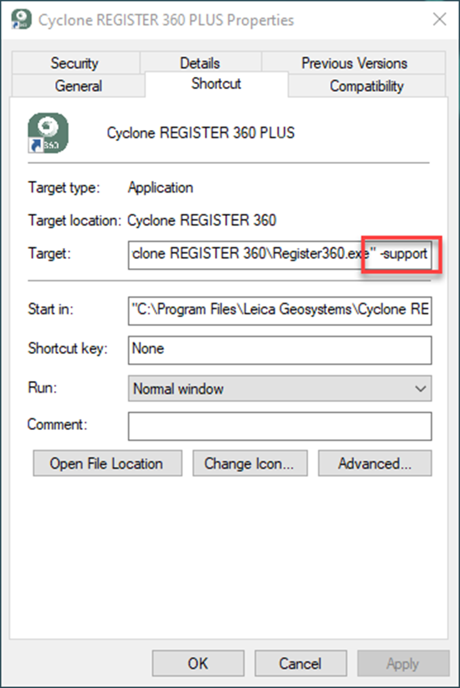
    1. Create a shortcut to Cyclone REGISTER 360 PLUS on the desktop if one does not exist.

    2. Right-click the shortcut and select Properties.

    3. Append -support to the Target field entry, separated by a space as shown below:

image-20240401-184143.png

d. Launch Cyclone REGISTER 360 PLUS via the shortcut.

e. Open a project that needs the cleaning restored.

f. Open the project requiring cleaning restoration.

g. In the Review & Optimize area, right-click SiteMap with the Bundle(s), and choose Restore Cleaning. Cleaning will be applied to all Bundles in the SiteMap.

image-20240401-184628.png

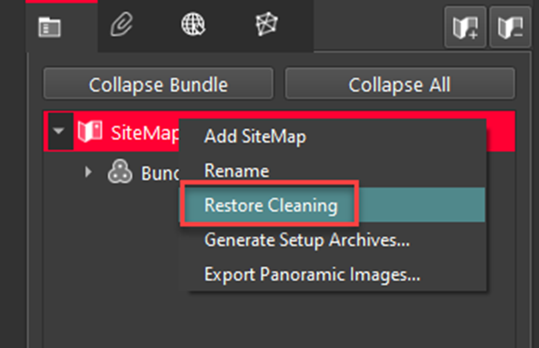
h. Proceed to the Finalize step, then to the Report step, and generate a new Finalized Registration.

i. Export using the desired structured format.

  • In rare cases, exporting structured data to RCP Setups with sub-sampling may result in some Setups being omitted from the final output. This occurs due to cloud editing where sub-sampling can reduce the points below the 500 x 500 minimum required by ReCap. Alternatively, it could be due to another limitation which can be worked around by either not using the sub-sampling, or separating the Setups onto multiple SiteMaps and exporting those SiteMaps separately. Make sure the data has Control applied for consistent coordinates between separate Finalized Registrations.

  • When exporting panoramic images of Setups using the Pano images option from Publish Options on the Report tab, the generated CSV and TXT files both contain the same position and orientation information, instead of providing Setup poses in the CSV file and pano image poses in the TXT file as expected.

RTC360 Issues

  • Importing RTC360 data into Cyclone REGISTER 360 PLUS cannot be completed successfully if RTC360 data contains non-ASCII characters.

BLK360 Issues

  • When importing BLK360 data that includes GNSS information directly from the scanner into Cyclone REGISTER 360 PLUS, it fails to load a satellite map and does not zoom in on the approximate location indicated by the GPS information from the scanner.

  • When importing BLK360 data that includes GNSS information directly from the scanner into Cyclone REGISTER 360 PLUS, the Select Coordinate System import option on the Properties panel is disabled. To activate the option, in the import area, either click a specific job or select or deselect any previously selected job.

BLK2GO Issues

  • When deleting jobs from BLK2GO using BLK Data Manager, the job is no longer visible in BLK Data Manager, but some metadata remains on the scanner and reappears when connecting to Cyclone FIELD 360.

BLK ARC Issues

  • As of version 2024.0.1, importing BLK ARC data, which includes static scans and Cyclone FIELD 360 links, directly into Cyclone REGISTER 360 PLUS is not fully supported. This is because the image assets and static scans may not be fully imported. The recommended method for full data import is using BLK Data Manager 2025.0.1.

  • Static scans captured with BLK ARC are missing from the dataset when imported into Cyclone REGISTER 360 PLUS using the direct import method. The workaround is to download a dataset via BLK Data Manager and then import it into Cyclone REGISTER 360 PLUS.

BLK2FLY Issues

  • The Advanced Colorizer import option does not work for B2G files captured with BLK2FLY. When selected, the import behaves the same as if the option were not selected. Therefore, using this option for such datasets is not recommended.

Visual Anomalies

  • After importing colourless scans with the enabled Auto B&W target option, thumbnails for the black-and-white targets appear invalid and display as blank or white after being extracted manually.

  • When a level condition is applied to Unified and LGSx Setups, the level condition icon does not update to reflect this change. To verify the level condition, use the Setup’s context menu.

Unexpected Closures and Failures

  • 30 GB of temp space is needed for every billion points exported to a single RCP cloud. Otherwise, Cyclone REGISTER 360 PLUS may become unresponsive or close unexpectedly.

  • When attempting to assign an asset to a GeoTag, the operation silently fails if the asset is already attached to another GeoTag and the TXT file is empty.

Deprecated Features

Leica Geosystems strives to provide support for the widest array of operating systems and file formats possible as is reasonable given current technologies and support from third-party partners.

With each release, we review our list of currently supported formats and operating systems in line with industry trends and announce product terminations.

Leica Geosystems may add or terminate support for a file format during any release. Obsolete operating systems will be supported for six months after their announced termination or the next major software release, whichever comes first. Server products will be supported in alignment with Leica’s Client License Manager (CLM) supported servers to guard users against incompatibility.

Cyclone REGISTER 360 2020:

  • TVG files are no longer published. Users should use the LGS format. If a TVG is required, users can Publish to TruView Local and run the dataset through the free utility Leica Pack&Go.

Cyclone REGISTER 360 2021:

  • Windows 7, 8, and 8.1 are no longer supported.

Cyclone REGISTER 360 PLUS 2023.0.1

  • FARO raw scan files from the newest FARO scanners are not supported due to a lack of availability in the FARO SDK.

Cyclone REGISTER 360 PLUS 2023.0.0:

  • Publishing to TruView Local and JetStream Enterprise is no longer supported.

Cyclone REGISTER 360 PLUS 2023.0.3:

  • ZFC scanner data files are no longer supported due to a lack of updated supporting MS redistributables.

  • iStar Camera images are no longer supported due to the lack of updated supporting MS redistributables.

Cyclone REGISTER 360 PLUS 2023.0.3:

  • This release of Cyclone REGISTER 360 PLUS will only support MS redistributables supported by Microsoft.

Cyclone REGISTER 360 PLUS 2026.0.0:

  • Windows 10 is no longer supported.

Licenses

All users with valid CCP for either Cyclone REGISTER 360 or Cyclone REGISTER 360 PLUS or Cyclone REGISTER, or with CCP valid as late as 30 November 2025, can run this new version of Cyclone REGISTER 360 PLUS with no new license required.

All users with valid CCP for Cyclone REGISTER 360 (BLK Edition) or Cyclone REGISTER 360 PLUS (BLK Edition) or with CCP valid as late as 30 November 2025 can run this new version of Cyclone REGISTER 360 PLUS (BLK Edition) with no new license required.

Users do not need to migrate to a Cyclone REGISTER 360 PLUS or Cyclone REGISTER 360 PLUS (BLK Edition) license in order to run Cyclone REGISTER 360 PLUS if their CCP or subscription is valid.

JavaScript errors detected

Please note, these errors can depend on your browser setup.

If this problem persists, please contact our support.